Sponsors of cranbrook.org 
Français Deutsch Italiano Español Portuguse
Aerial view of Cranbrook
Home 
About Cranbrook 
A to Z Directory 
Shopping 
What's On? 
Accommodation 
Places to Visit 
Travel Information 
Maps & Leaflets 
Trips 
Food & Drink 
Businesses 
Schools 
Health 
Clubs & Societies 
Sports & Leisure 
Churches 
Links 
Message Board 
EMERGENCY 
Why Cranbrook?

Maps & Leaflets

National map

Regional map

Town plan

Aerial Photograph (click to enlarge)

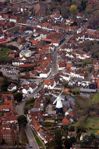
© The Courier Media Group Ltd

To find the location of anywhere mentioned on the website for which a postcode is shown, click here and paste or type the postcode into the box under find a place and click on the find button.

The interactive maps at Google are also useful - and good fun!

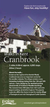
The leaflet shown below is produced by Kent County Council and details a very pleasant three mile circular walk starting in Cranbrook. Please click on the image to download an Adobe pdf file which you can view on your computer or print.

(Requires free Adobe software - download here)


Walks in Kent

See also

Walking in Kent
www.walkinginkent.co.uk

Walking Routes
www.walking-routes.co.uk

top   back   bookmark

A B C D E F G H I J K L M N O PQ R S T U V W XYZ

Advertise here
The Creative Dance Company
PROFIT from our advice
SPICE

Advertise here


Disclaimer  |  Privacy Policy  |  email Webmaster   |  top

Site coding and text © 720720 Group 1995-2010
Photography © Rodgers Photography

www.cranbrook.org - The Official Website of Cranbrook - Capital of The Weald of Kent